Getting here
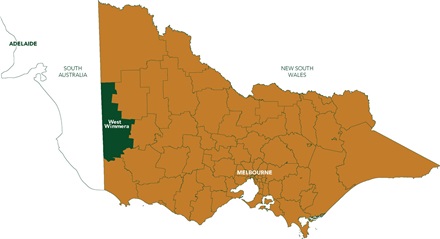
Situated along the Victorian-South Australian border, West Wimmera covers 9,200 square kilometres of predominantly agricultural land and includes the townships of Apsley, Edenhope, Harrow, Goroke, Kaniva, Dergholm and Serviceton.
From Melbourne: Follow the National Highway A8 West for approximately 5 hours to Kaniva and then follow local directions to additional townships.
From Adelaide: Follow the National Highway M1 East for approximately 3.5 hours to Kaniva and then follow local directions to additional townships.
From Mt Gambier: Follow the A66 and the Dorodong Rd for approximately 1 hour to Dergholm, or follow the Riddoch Highway for approximately 1.15 hours to Apsley.
From Warrnambool: Follow the Glenelg Highway B160 for approximately 2.5 hours to Dergholm.
From Ballarat: Follow the Western Highway M8 for approximately 3.5 hours to Goroke.
From Geelong: Follow National Highway M1 for approximately 4.5 hours to Goroke, or follow Glenelg Highway B160 for approximately 4.5 hours to Edenhope.
You can use Rome2Rio to plan your transport/trip to our region: https://www.rome2rio.com/
| Township |
Distance to Adelaide, SA |
Distance to Horsham, VIC |
Distance to Melbourne VIC |
| Serviceton |
292.7 Km |
139.7 Km |
438.5 Km |
| Kaniva |
312.7 Km |
114 Km |
412.8 Km |
| Edenhope |
378.3 Km |
96.4 Km |
388.2 Km |
| Goroke |
371.8 Km |
68.2 Km |
366.8 Km |
| Harrow |
411.4 Km |
79.2 Km |
361.8 Km |
| Apsley |
358.5 Km |
114 Km |
408 Km |
| Dergholm |
404.8 Km |
136.2 Km |
399.1 Km |